
Understanding the Storm Alert: What You Need to Know
As we brace ourselves, it’s crucial to understand the impending weather conditions. Today and tonight are designated as Storm Track 7 Yellow ALERT DAYS. This isn’t just a casual weather update; it’s a call to be prepared. The primary concern is the threat of strong to severe storms, capable of delivering damaging wind gusts exceeding 60 mph. But there’s more: a secondary threat looms in the form of isolated tornadoes and large hail. What does this mean for you? It means vigilance. Keep an eye on the sky, pay attention to weather updates, and have a plan in place. Whether you’re at home, work, or on the road, knowing the potential risks allows you to take the necessary precautions. Remember, being informed is the first step in staying safe during a storm.
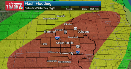
Specific Threats: Wind, Hail, and Flash Flooding
The potential for damaging winds is significant, capable of causing property damage and posing a danger to anyone outdoors. Expect these winds to potentially knock down trees, cause power outages, and make driving hazardous. Then there’s the threat of large hail, which can dent vehicles and damage property. Moreover, flash flooding is a serious concern, especially in areas experiencing sustained heavy rainfall. The forecast predicts that some areas could receive 3-6+ inches of rain. This amount of rainfall in a short period can quickly overwhelm drainage systems, leading to flooded roads, swollen creeks, and water in basements. Be aware of your surroundings, and never attempt to drive through flooded areas. The hidden dangers beneath the water can be deadly.
Today’s Weather: A Day of Increasing Risks
Today, the risk of rain and storms will increase throughout the day. As the cold front approaches, the cloud cover will also increase. Expect multiple rounds of storms, with the greatest severe risk occurring in the afternoon to overnight hours. The National Weather Service has issued a Level 2 of 5 Severe Risk and a Flood Watch for today. Temperatures will be in the low 80s to near 90 degrees, and the humidity will remain high. A southeast breeze at 5 to 10 mph will provide some slight relief from the heat, but it won’t diminish the severity of the storms. The changing weather patterns highlight the need to stay informed and prepared. Make sure to monitor weather alerts, and be ready to take shelter if necessary.
Tonight’s Forecast: More Heavy Rain and Strong Storms
Tonight, the threat of severe weather continues. Torrential downpours and strong storms are expected to redevelop, particularly in areas along and south of Highway 20. The atmospheric conditions are expected to support “training thunderstorms,” where heavy rain continues to fall over the same areas for extended periods. This is a critical factor in the risk of flash flooding. Expect some flooded roads, swollen creeks, and the potential for water in basements. The lows will be in the upper 60s to low 70s, with a southeast breeze at 5 to 10 mph. The potential for flooding will be particularly high in the areas affected by training thunderstorms. Avoid travel if possible, and make sure to have emergency supplies on hand.
Sunday’s Outlook: Continued Risk with a Possible Lull
Scattered showers and storms are possible through Sunday, with mostly cloudy skies. There may be a lull in activity for much of the day. The severe threat is not as high as today or tonight. Highs will be in the low 80s, but the humidity will linger, with a light south wind. However, rain and storms are likely Sunday night due to a nearby stationary front. This could bring stronger wind gusts, heavy downpours, and the continued risk of flooding. Even though the severe risk may be somewhat diminished, the potential for flash flooding remains a significant concern. Keep monitoring the weather, and be prepared for changing conditions throughout the day and into the evening.
Looking Ahead: Next Week’s Weather Pattern
Next week, we can expect some on-and-off rain and storm chances through about Wednesday before drier conditions prevail. Highs will be seasonal, in the low to mid-80s, with humid conditions. This pattern suggests that the weather may remain unsettled for several days. It is important to stay informed about any changes in the forecast. Being aware of the weather conditions will help you plan your activities and prepare for any potential severe weather. Remember, the best way to stay safe is to stay informed and be prepared.
Concluding Thoughts: Staying Safe and Prepared
In conclusion, the next few days will bring a heightened risk of severe weather, including damaging winds, potential tornadoes, large hail, and the threat of flash flooding. It’s essential to stay informed by monitoring weather updates from reliable sources. Have a plan in place, including knowing where to seek shelter if necessary, and preparing emergency supplies. Be aware of the specific risks in your area, and take the necessary precautions to protect yourself and your property. While we can’t control the weather, we can control how we respond to it. By staying vigilant and prepared, we can navigate these challenging conditions safely. Stay safe, and make sure to keep checking for updates as the weather evolves.